copy the linklink copied!Chapter 2. Main approaches and challenges in defining functional areas
This chapter outlines the main approaches used for identifying functional areas in OECD countries. It discusses both core-based as well as multidirectional-flow-based approaches and lays out their most important elements. The chapter also presents key challenges of those approaches in terms of data availability, geographic building blocks, and sensitivity analysis of results.
This chapter discusses and highlights major differences between existing methods to delineate functional areas. It explores approaches to potentially map functional areas in countries where these types of geographies do not yet exist. In so doing, it sets the stage for the mapping exercise presented in this report, for a number of countries where these methods are less frequently used, and discussed in detail in Chapter 5.
The potential benefits of integrating functional areas into the work stream of national statistical offices (NSOs) go beyond the OECD area. An understanding of existing methodological options can help accession countries and non-OECD countries adopt functional area geographies, which will allow them to increase the precision and efficiency of their regional development policies.
To delineate functional areas in all territories, various OECD countries adopt a method based on analysis of multidirectional commuting flows across territorial units, hereafter referred to as a multidirectional-flow-based method. As such, local labour markets are the most commonly used concept for delineating functional areas for a country’s entire national territory. They consist of the local area where labour demand and labour supply meet and contain a territory that has significant internal commuting activity but low levels of work-related travel that cross its boundaries.
This chapter mainly focuses on the prevailing approach, which: i) identifies clusters according to multidirectional commuting flow intensity instead of urban seeding; ii) builds on using the smallest possible administrative unit; iii) exploits commuting flow data; and iv) extracts information from census sources. However, the methodological implementation can differ across countries in the criteria used in terms of self-containment and population size that a cluster needs to satisfy to yield a functional area.
The following subsections explore some of the major elements that define and can give rise to different approaches for delineating functional areas. The next section discusses the essential distinction between the most common core-based approach and non-core-based approaches for identifying functional areas. Across countries, data sources and geographic building blocks often differ. Furthermore, this chapter also refers to country contexts where commuting flow data between small administrative units are not available and presents some case study examples on how functional areas can nonetheless be identified. The output of different methods depends significantly on the choice of model parameters, which might vary by country, and outcomes can thus be sensitive to that parameter choice, which this chapter discusses. Finally, the chapter concludes with a discussion of further remaining challenges and open questions.
In recent years, some OECD countries have implemented functional areas for their entire national territory. Based on their set of experiences, the concept is now mature enough to deserve a discussion on advantages and disadvantages of existing methods and their data sources as well as on possible recommendations for better comparability across countries (see this chapter and Chapters 3 and 4).
copy the linklink copied!Core-flow-based versus multidirectional-flow-based
Historically, the analysis of functional areas has focused on the metropolitan milieu. In this perspective, linkages between territorial units were generally represented by commuting flows from peripheral, residential areas to core metropolitan areas. This simplification of commuting patterns was also facilitating the computational procedure for the delineation of functional areas, as relatively straightforward rules could be applied to determine the boundaries of such a functional area. The experience of many OECD countries reflects this historical trend, further evidenced by the existing definition of functional urban areas (FUAs) (OECD, 2002[1]).
More recently, data availability and computational capacity on the one hand, combined with a more comprehensive conceptualisation of functional areas on the other hand, have enabled the development of multidirectional-flow-based approach to the delineation of functional areas. A high-level view of these two approaches is represented in Figure 2.1. The core-flow-based approach is usually centred around a city and then includes adjacent areas of economic influence or commuting (this approach is also referred to as urban seeding). The multidirectional-flow-based approach considers all mobility flows between different geographic areas to establish their functional relationship. In so doing, it generally provides a more comprehensive representation of linkages between territorial units. While the former approach partitions the territory top down, the latter clusters building block areas bottom up.
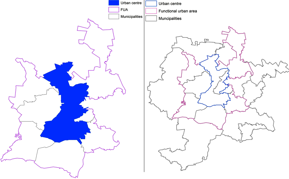
Note: The figure presents the two main approaches to defining functional areas for San Luis Potosí (Mexico). The core-based approach (left) is based on the flow from administrative units (municipalities) to the urban centre (core). The flow-based approach (right) considers the flows between all administrative units.
Source: Produced by the OECD, 2019.
Multidirectional-flow-based approaches are emerging as the prevailing approach in the mapping of functional areas and therefore constitute the focus of this report. However, functional areas defined by multidirectional flows do not substitute core-flow-based areas, such as FUAs. In fact, they represent different concepts that may also serve different purposes. While FUAs consist of nodal commuting flows to a central place, usually a city of a minimum size, and cover a limited territory around those places, functional areas result exclusively from commuting flows between small administrative units and aim to cover the entire territory of a country (Eurostat, 2017[2]).
As discussed in previous work, the distinction between the two approaches can be broken down into a number of key differences (Figure 2.2). First, FUAs are a core-based concept whereas functional areas derive from flow-based analysis.1 Second, FUAs are limited to the territory surrounding cities while functional areas cover countries’ entire territory. Third, the computation of FUAs is less demanding. In comparison, the delineation of functional areas entails a multistep algorithm procedure that requires specific information technology (IT) packages in software such as R or Python. Fourth, the multidirectional flow approach is able to cope with the rapidly growing phenomenon of polycentric urban regions. Finally, small-area-estimation techniques are harder to apply to functional areas due to their geographic configuration and potentially small size.
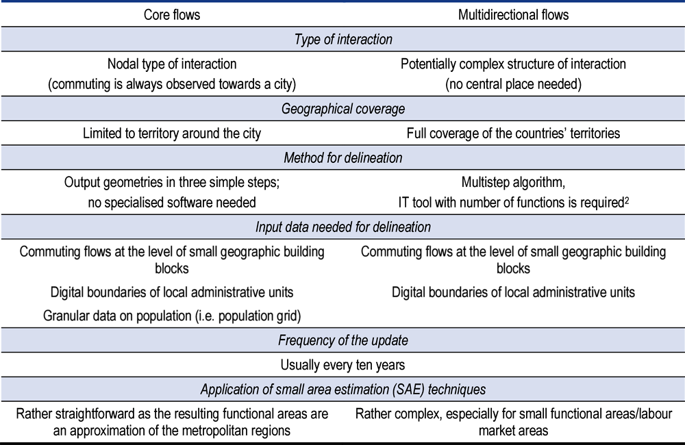
Source: (Eurostat, 2017[2]).
copy the linklink copied!Geographic building blocks
The underlying geographic building block of subnational data used for the delineation of functional areas is pivotal for functional areas’ accuracy. Ideally, the building block should be as granular as possible to provide the highest achievable accuracy of the estimation of functional areas, as long as there are reliable data for such small areas. In general, this means that data should be below the TL3 level. For many countries, such as Korea (see Chapter 5), Mexico or most European Union (EU) countries, data at the municipal level provide the building block for delineating functional areas.
In many cases, building blocks consist of small administrative units such as municipalities, which can, however, vary significantly across OECD countries in terms of geographic extent and population size. The level of detail of building blocks then directly affects the granularity of delineated functional areas. For research purposes, this report explores the delineation of functional areas in a few countries and the respective building blocks of choice for each country will be described (Chapter 5).
Data
The most important source for commuting data is generally national censuses. The information on individuals’ place of work and place of residence enables the compilation of aggregate commuting flow patterns between different administrative areas such as municipalities or census tracts. The resulting commuting matrix provides the input data for the algorithm that identifies clusters, i.e. geographic areas with considerable reciprocal mobility patterns.
Commuting patterns are the primary factors in defining and delineating functional areas because they elicit the degree of economic integration between two places as measured by the extent to which workers are willing and able to commute between those two places (Eurostat, 2017[2]).
Additional sources of commuting flow data
A number of alternative data sources to censuses have emerged that can provide useful information for identifying functional areas. The most prominent example is administrative data sources, in particular tax record or employment and business records, in particular national registers of people, business and activities. Several NSOs have developed or are currently developing systems of national registers, which can provide information on the place of residence and the place of work of individuals. In turn, this information can help to estimate mobility flows for any level of geographic aggregation.
Such data can be particularly useful in cases where the collection of commuting data is burdensome and only conducted at irregular intervals. Administrative sources and national registers offer an alternative to census-based commuting flow data that are less cost-intensive and easier to update on a frequent basis.
The emergence of new mobility flow data
In some countries, commuting data are not, or only infrequently, collected through censuses. Furthermore, a number of countries that historically included questions on commuting patterns in their census are currently contemplating a revision of their census that would preclude commuting data. In such contexts, non-traditional data sources and approaches may offer an alternative way of delineating functionally, i.e. economically, integrated areas.
Unconventional data sources such as mobile phone data or credit card data often contain geo-localised information. As a result, mobility patterns of individuals can be detected. Consequently, such data may allow approximations of travel-to-work flows and also provide information on geographic patterns of other economic activity such as consumption.
While commuting data are at the core of the default approaches of delineating functional areas, the availability of mobility flow data is limited in some countries and regions of the world. Usually, national statistics institutes integrate questions on commuting in their national census. Yet, many countries do not collect such information.
Novel approaches building on new sources of data could offer a solution that mitigates a lack of commuting data. Several case study examples indicate how data on mobility derived from mobile phones or credit cards can reveal similar information to commuting surveys:
-
Mobility patterns extracted from mobile phone data can yield spatial flow data that help to estimate or approximate work-flow travel. The example of Estonia, discussed in Chapter 5, shows how such data can help to identify territorial linkages between different areas and thus enable the delineation of functional areas.
-
Another alternative has emerged through the availability of data on credit card transactions. Exploring the underlying geographic information in financial transaction data can produce spatial patterns of economic activity. Such data even accommodate an additional distinction of functional integration of areas according to the time of the day and year of transactions and thus mobility flows. In a recent study, anonymised records of bank card transactions in Spain helped to develop a new classification of cities with respect to the economic behaviour of their residents (Sobolevsky et al., 2016[3]). Another study uses credit card transaction data to develop a methodology for identifying a cardholder’s “usual environment” (Arias et al., 2018[4]).
copy the linklink copied!Approaches without mobility flow data
For specific geographic areas or non-OECD countries in which data availability is very limited, buffer approaches offer yet another alternative to delineating functional areas. Even if commuting data do not exist, road network data are usually available. Hence, drawing a simple zone of, for examples, 10-20 km along the main road network or specific travel times around core urban areas provide a rough approximation of the area of economic influence of an agglomeration. However, such zones do not truly reflect the functional integration of different areas and should thus be seen as second-best option.
copy the linklink copied!Specifications and sensitivity
Delineating functional areas requires country-specific knowledge of, among other things, administrative divisions and commuting patterns. Across countries, administrative units of the same scale can vary in terms of population, area and commuting patterns. The methodology to delineate functional areas captures these differences by allowing users to specify size and self-containment requirements for functional areas.
The size parameters describe the minimum size and target size of a functional area. The self-containment parameter describes the level of self-containment (i.e. people that live and work in the area) required. Generally, the parameters are set so that as the size of the functional area increases the required level of self-containment decreases. In other words, functional areas with a small number of people require a higher share of people living in the area than a larger functional area.
These parameters can be modified to ensure that functional areas provide meaningful agglomerations and are not too large or small for statistical purposes. Chapter 4 provides a technical overview of the process.
The size and self-containment can be also applied when delineating functional areas at different scales within the same country. For instance, commuting data may be available at different levels of geography. More disaggregated scales may yield more precision but may come with more noise. As the geographic units become smaller, there is a higher chance of obtaining isolated functional areas that do not have any linkages. In these cases, it may be useful to aggregate units to reduce the noise in the data and ensure consistent results.
copy the linklink copied!Challenges in analysing and integrating outputs
This section presents and briefly discusses some of the most important challenges in analysing and integrating outputs of methods to delineate functional areas. The subsequent methodological discussion shows prevailing or possible solutions to address these issues. Nonetheless, it should be once again acknowledged that functional areas might not be suitable for all geographic contexts and for all statistical purposes.
The “functionality” challenge
While functional areas can make a valuable contribution to policy making and programme delivery as well as territorial statistics, they might in some cases yield new challenges. For example, clusters identified by commuting flows may, in fact, be impractical from the perspective of service provision or accessibility. In other cases, they might still not reach sufficient critical mass that warrants a dedicated system of public services and infrastructure.
Isolated areas and very small administrative units
Although functional areas ideally offer a meaningful grouping of small administrative units for the entire territory, they might encounter technical difficulties in isolated parts of a country. For example, very small administrative units that are extremely isolated might pose the question of how to integrate and cluster them. This problem can be particularly challenging in large but very sparsely populated regions as is common in Canada but also in parts of Northern Europe. Similar issues arise if information on geographic mobility or commuting patterns is relatively coarse, i.e. only exists for large administrative units that might not fully reveal the exact geographic pattern of commuting between subareas of those administrative units.
Coherence with pre-existing geographic classifications
Any exercise aimed at creating a new geographic concept or even updating and upgrading an existing one faces the challenge of coherence and possible integration with pre-existing concepts and geographic classifications. This challenge is far more compelling when existing geographic concept are deeply entrenched in policy and regulatory frameworks, legislation and delivery of public programmes.
The treatment of pre-existing core-based FUAs is the most salient case, which is made even more sensitive by the similarity between alternative concepts of functional areas (core- versus multidirectional-flow-based). In countries such as Canada and the US, urban core-based functional areas have become an established geography. They are used to disseminate official statistics and also inform policy design and action in domains ranging from housing to transport planning. The pre-existence of such FUAs (or metropolitan areas) constitutes a challenge in finding public acceptance of another potentially overlapping geographic concept.2
Therefore, statistical offices face an important choice of including or excluding the administrative areas covered by existing metropolitan areas in their flow-based approach for delineating functional areas. In some countries, the policy and programme relevance of the former might imply that functional areas could only be defined for the remaining national territory and thus offer a complement to metropolitan/functional urban areas. This report presents results for a pragmatic approach to address this type of challenge, which integrates delineated functional areas with pre-existing territorial units, where necessary.
Planning for historical revisions
To remain relevant, functional areas would necessarily be “updated” from time to time or on a regular basis. This requires NSOs to adequately plan for such revisions and take the needed preparatory steps. Contrary to administrative areas, functional areas can evolve, merge or even disappear over time, depending on changing mobility pattern, migration or a shift in economic activity. To capture such changes in territorial linkages, relevant data need to be collected and analysed on a regular basis. In the past, the re-delineation and review of functional areas was a tedious and time-consuming affair. However, open-source programmes with functionality targeted at the specificities of deriving functional or labour market areas are increasingly available. Therefore, any revision of functional areas become less demanding in terms of time and effort.
References
[4] Arias, J. et al. (2018), “Using transactional data to determine the usual environment of cardholders”, in Information and Communication Technologies in Tourism 2018, Springer, Cham.
[2] Eurostat (2017), The Concept of Labour Market Areas – Summary Report.
[1] OECD (2002), Redefining Territories: The Functional Regions, OECD Publishing, Paris, https://dx.doi.org/10.1787/9789264196179-en.
[3] Sobolevsky, S. et al. (2016), “Cities through the Prism of People’s Spending Behavior”, Plos One, Vol. 11/2.
Notes
← 1. The description of functional urban areas (FUAs) apply generally to most types of FUAs, i.e. not only OECD FUAs but also United States metropolitan areas.
← 2. Although the US does not currently have officially recognised functional areas in all territories, the Bureau of Labor Statistics uses their own set of labour market areas (LMAs): https://www.bls.gov/lau/laugeo.htm#geolma. Additionally, the US Bureau of Economic Analysis’s economic areas present another example of a functional geography beyond metropolitan areas. However, they have neither been updated since 2004 nor used for official statistics since 2013.
Metadata, Legal and Rights
https://doi.org/10.1787/07970966-en
© OECD 2020
The use of this work, whether digital or print, is governed by the Terms and Conditions to be found at http://www.oecd.org/termsandconditions.