
5. Delivering accessible and sustainable mobility
This chapter is dedicated to the transport sector, with a focus on surface transport. It discusses policy priorities that are central for the sector to contribute to current and future well-being objectives. The chapter proposes a number of indicators that can be used to translate the discussed policy priorities into measurable outcomes, and can support policy makers in attaining a two-way alignment between climate and other policy goals. The chapter also examines the relation between the indicators proposed, and indicators used by the Sustainable Development Goals and the OECD Framework for Measuring Well-being and Progress.
Mobility systems connect people and places, increasing quality of life as well as adding social and economic value to communities. The transport sector underpins peoples’ well-being by enabling them to travel between their home and work, delivering food to our grocery stores, and transporting products around the world and within countries, regions and cities to meet our daily needs.
However, emissions from transport have grown faster than any other sector over the last 50 years, accounting for approximately 23% of global CO2 emissions. This largely stems from the fact that mobility systems over the last century have aimed to increase physical movement, are heavily reliant on fossil fuels, and are centred on private ownership, which has in turn led to cities planned around cars. Today’s mobility systems also lower our air quality, entrench social inequalities, exclude vulnerable groups, deteriorate natural habitats and exacerbate climate change. If our mobility systems do not change, then transport CO2 emissions could increase by 60% globally by 2050.
The solution is to re-design mobility systems around accessibility - ensuring that people are able to easily reach jobs, opportunities, goods, services and amenities – instead of physical movement. This would mean giving priority to sustainable transport modes, such as walking, cycling, public transport and other forms of shared mobility, and even new modes (e.g. electric scooters known as micro-mobility), which can bring relevant value to society, particularly in cities. It would also entail giving priority to creating proximity between people and places. Such an approach will lead to a redistribution of budgets and public space in a way that can improve life quality by contributing to equity, health, the economy, climate and other environmental goals.
An important next step is developing and using the right indicators to make the focus on accessibility a reality. The use of physical accessibility indicators for planning transport networks and city development has allowed some cities to reach important modal shift targets- i.e. incentivising people to bike, walk, and use public transport instead of the car. Indicators incorporating transport affordability as criteria for supporting social and affordable housing development have also allowed cities to improve both housing and transport affordability for poorer households while achieving climate change mitigation goals. Governments will also need to set criteria according to safety and security, air quality, noise reduction, and impacts on natural habitats, in order to transform mobility systems.
Policies for improving technologies, but also for avoiding unnecessary trips and shifting trips from cars to bikes, public transport, and walking, will be necessary for decarbonising the sector while bringing multiple other benefits. But the transport sector needs to co-ordinate closely with land-use and housing sectors to ensure access through sustainable modes of transport that provide a high-quality alternative to cars. This involves investment on sustainable transport modes but also policies that can make explicit links between land-use and transport (e.g. transport-inclusive development standards). Overall, policy design that takes multiple priorities into account can lead to more acceptable, feasible and effective mitigation action.

Chapter 1 of this report argues for applying a well-being lens to policy making, explaining why this is key to ensuring a two-way alignment between climate and broader well-being goals. Adopting a well-being lens implies that societal goals are defined in terms of well-being outcomes (climate change risks and impacts included), and are systematically reflected in decision-making across the economy. It also entails that decisions are taken keeping multiple well-being objectives in mind, rather than focusing on a single (or very narrow range of) objective(s). Finally, the interrelations between the different economic sectors and systems in which a policy intervenes should be sufficiently well understood. This chapter applies the well-being lens to the transport sector.
The transport sector is a key enabler of human activity, hence well-being heavily depends on its performance and characteristics. Mobility systems connect people and places, bringing important economic and social added value, and increasing life quality. Nonetheless, mobility systems can also generate a series of negative impacts on well-being, by polluting the air; threatening user’s lives and physical integrity (e.g. through high risks of accidents); increasing economic and social inequalities, and the social exclusion of vulnerable groups; and even causing habitat loss and degradation. Mobility systems are also important emitters of global greenhouse gases (GHG), significantly contributing to climate change.
Global carbon dioxide (CO2) emissions from transport increased by 63% between 1990 and 2014 (OECD/IEA, 2019[1]). Over the past 50 years, emissions from the transport sector have grown faster than in any other sector, with CO2 transport emissions accounting for 23% of global energy-related CO2 emissions in 2014 (IPCC, 2018[2]). In terms of composition, emissions from surface passenger transport accounted for almost 50% of total global CO2 emissions from transport in 2015 (ITF, 2017[3]), largely as a result of growth in private-vehicle ownership and use (ITF, 2017[3]), even in urban areas where density of demand provides a potentially larger scope for non-motorised and public transport (Aguilar Jaber and Glocker, 2015[4]). International and domestic aviation accounted for 10% of transport CO2 emissions in 2015, surface freight (road and rail) 28%, and sea and air freight 12% (ITF, 2017[3]).
If current conditions persist, there is no prospect of reversing this upward trend in transport emissions anytime soon. Improvements in vehicle technology, particularly fuel efficiency, are likely to continue. However, the sector is still heavily reliant on fossil fuels, and significant growth in global transport volumes is expected in the coming decades. Under the current trends, total passenger and tonne-kilometres are expected to grow by a factor of three between 2015 and 2050 (ITF, 2019[5]). Even in a scenario where current and announced policies are implemented, transport CO2 emissions will still increase by 60% by 2050 (ITF, 2019[5]) – far from projections of where the sector would need to go to be consistent with well-below 2 degrees Celsius (°C) and 1.5°C scenarios. While integrated assessment models project the necessary CO2 emission reductions in the transport sector to be far smaller than reductions in sectors like electricity (and other demand-side sectors), in scenarios with a greater than 67% chance of staying below a 2ºC goal (Luderer et al., 2018[6]), they still need to fall modestly by 2050, relative to 2010 levels (ranging from non-growth to - 25% according to the different 2ºC pathways). Achieving a 1.5°C goal would require much deeper cuts in transport emissions by 2050 (ranging from -25% to -75%, according to different 1.5ºC pathways) (Luderer et al., 2018[6]).
How the transport sector evolves – e.g. whether systems based on private ownership and low vehicle-occupancy rates persist, or more sustainable modes (e.g. walking, cycling, and public and other shared mobility modes) gain a prominent role – will be key to the sector’s contribution to climate change mitigation and multiple other well-being goals. As in other sectors, the development of new technologies is an important driver for change. Three “revolutions” have been particularly identified as “game changers” (Fulton et al., 2017[7]): 1) the increasing availability and decreasing cost of low- and zero-emission vehicle technologies; 2) the development of automated vehicles; and 3) the development of new business models made possible by digitalisation, such as ride-hailing and “on-demand” shared mobility services (Fulton et al., 2017[7]). In addition, technology has also increasingly allowed the emergence and growing role of new transport modes (e.g. electric vehicles and scooters, often called micro-mobility). Several governments are also looking into mobility as a service (MaaS) as the desired model for using technologies to improve transport services. The Finnish government, for instance, passed the new Act on Transport Services in 2018, with the aim of promoting MaaS, which it defines as providing the following advantages: “[T]hrough technology information and innovations, transport services become a customer-oriented service, in which the boundaries between transport modes disappear and transport chains will be smooth” (ITF, 2018[8]). The policy framework in which these technologies, stakeholders and models evolve will determine their role, as well as their ultimate impact on shaping mobility systems and delivering climate change mitigation and other societal goals.
Section 5.2 argues that applying a well-being lens to the transport sector requires rethinking mobility policies, investment priorities and planning. The focus needs to shift from generating physical movement to delivering access to economic, social and environmental opportunities, by improving physical accessibility, affordability and road safety (particularly through sustainable modes). Discussions emphasise potential synergies and identify potential trade-offs needing to be managed when undertaking climate action in the sector. They examine how the proposed change in perspective can enhance synergies and minimise/mitigate trade-offs. Section 5.3 proposes several indicators that could be used to better track and evaluate the transport sector’s contribution to wider well-being and the Sustainable Development Goals (SDGs). Based on examples from different countries and cities, it discusses how using such metrics allows tracking progress in terms of different policy priorities and gaining a better understanding of how mitigation actions can impact on other dimensions of well-being and vice versa, facilitating the two-way alignment discussed in Chapter 1. This chapter has a stronger focus on passenger surface (i.e. road and rail) transport, although a shift to accessibility-based systems will directly impact on the efficiency of surface freight modes (including by giving the transport of goods priority over private cars), with implications for their regulation. Also, many of the indicators discussed throughout the chapter, as well as the impacts covered are as important to monitor the performance of passenger as freight transport modes.
It is important to be clear about the desired outcomes from transport policies. More physical movement does not necessarily result in better outcomes in terms of well-being and sustainability. Congestion and other negative externalities, as well as the excessive time and money spent by certain groups on travel, can all significantly reduce disposable incomes, exacerbate inequalities, and damage health and the environment. Evidence exists that car-centred planning, based on a “predict-and-provide” approach (i.e. predicting traffic and providing road infrastructure accordingly) leads to additional car traffic (induced demand). It does not ease congestion or reduce environmental externalities (including a range of other pollutants co-emitted with CO2 emissions), nor does it contribute to widespread access to opportunities for the population.
Evidence of induced demand was generated in the early 1990s in Europe, and growing evidence both in Europe and elsewhere has since contributed to a progressive revision of the rationale behind mobility policy and investment in transport infrastructure (OECD, 2016[9]).1 Shifting the focus behind policy decisions and investment from following mobility demand (passenger and tonne-kilometres) and increasing speed to improving accessibility, i.e. the ease of reaching destinations for goods, services, jobs and other activities (Litman, 2008[10]), has increasingly been recognised as a more adequate means of delivering sustainability goals. Nonetheless, important challenges remain in expanding accessibility-based planning and policy, as analysed by (Silva and Larson, 2018[11]). One of the most important issues is the common confusion between mobility and accessibility, leading to the general assumption that mobility is equal to or at least a good proxy for accessibility. Consequently, policies and planning often still focus strongly on increasing mobility, even when the word “accessibility” is used (Silva and Larson, 2018[11]).
These issues are reinforced by the correlation of transport volume measures (e.g. passenger and tonne-kilometres) with gross domestic product (GDP) and GDP per capita. The effect has often been interpreted as mutually reinforcing: as the economy grows and incomes rise, more transport activity is generated. At the same time, more transport activity contributes to more connections and economic activity, leading to economic development.
The correspondence between physical movement and speed, and effective access to activities and opportunities – let alone other dimensions of well-being, such as air pollution – is, however, imperfect (ITF-OECD, 2019[12]). In many cases, overall transport volumes can be high precisely because accessibility is limited, causing people and/or freight services to travel longer distances and incur higher expenditure on travel, while generating greater CO2 emissions and air pollution (which costs are not reflected or positively accounted for in GDP). One example is when limited accessibility by public transport generates higher car travel. Other examples are when destinations are located far away from trip origins, increasing travel distances, and/or accessibility by walking and cycling is difficult or unsafe, generating more travel on motorised modes in both situations. Thus, while keeping track of transport volumes will still be key to understanding emission drivers and demand trends, their inadequate use as measure of ultimate performance for the sector needs to be acknowledged (this is further discussed in Section 5.3).
Important opportunities exist for generating two-way alignment between climate change mitigation action, and broader well-being and sustainable development objectives in the transport sector, by focusing on accessibility instead of mobility. Such a shift in perspective can better align decisions in the sector with well-being and the SDGs. Firstly, because it is improved access to opportunities and activities, rather than higher physical movement that is directly linked to generating well-being. Second, focusing on improving accessibility recognises the role and value of sustainable modes of transport. This includes potential opportunities for new transport modes (e.g. micro-mobility), which under a reconfiguration of road space allocation that would prioritise low-carbon and space efficient modes, could bring relevant benefits and avoid potential trade-offs (e.g. accidents). Third, an accessibility-based approach emphasises the importance of designing cities in a way that enhances proximity – which, although not in the hands of policy makers in the sector, is a key enabler for moving towards sustainable transport systems. All of this would support governments in delivering climate change mitigation and other policy priorities that are central to generating well-being, such as: enhancing physical accessibility, ensuring affordability of services, improving road safety. Indeed, analysing climate change mitigation policies through the lens of their impacts on other policy goals linked to the different dimensions of accessibility, as well as pollution, noise, related health impacts and other environmental damages, can increase their effectiveness and help avoid important trade-offs. These relations are summarised in Table 5.1 and further discussed in Section 5.3.
Focusing on accessibility instead of mobility is at the heart of the two-way alignment. It recognises the role and value of sustainable modes of transport and the importance of designing cities in a way that enhances proximity. Both conditions are central to the sector reversing increasing GHG emissions trends and delivering a wide number of other well-being objectives.
As argued in Chapter 1, a measurement system that supports governments in monitoring and assessing policies in terms of their multiple impacts on well-being is necessary. This section proposes and discusses a range of indicators that are not widespread, but can improve policy makers’ ability to monitor progress towards climate and other well-being policy goals. The section provides a way to better capture the potential synergies and trade-offs created by different decisions and policies, by drawing on examples of how this type of assessment and tracking is being initiated in some countries and cities.
Discussion on different indicators is structured according to the five policy priorities identified in Section 5.2 as being key for the sector to achieve wider well-being and sustainability goals: limiting climate change; enhancing physical accessibility; ensuring affordability of services; improving road safety and security; and reducing local pollution and noise, associated health risks and habitat damage. Table 5.2 summarises the links between these policy priorities and SDG goals and targets, as well as with different dimensions and domains of the OECD Framework for Measuring Well-being and Progress (henceforth the OECD well-being framework).
Summary tables in each subsection show indicators that could be used as tools to translate the different policy goals into measurable outcomes. They also show the link between the indicators proposed and those used for the specific SDG targets, and the well-being domains and dimensions set out by the OECD well-being framework. As discussed throughout the section, the indicators proposed complement those already used in the SDG and OECD well-being frameworks by: a) contributing sector-specific disaggregated data to understand performance towards the SDG target and/or well-being; or b) improving understanding of the transport-related enabling conditions needed to achieve the SDG targets and/or well-being goals.
The indicators discussed throughout this section are not exhaustive. Rather, the analysis here is suggestive and intended to open discussion by highlighting data limitations and potential data enhancements, as well as illustrating good practice where improved indicators are already proving valuable.
5.3.1. Limiting climate change
Monitoring GHGs from transport is a way of directly quantifying the sector’s contribution to climate change mitigation goals. As stated before, CO2 emissions from transport account for around 23% of world energy-related emissions and have grown continuously over the last decades.
Data on CO2, and in some cases GHG emissions from the transport sector, are more or less available at the national level. A growing number of countries have developed emission inventories, which include specific GHG emissions from the transport sector. However, inventories for the transport sector are often estimated by using national data on fuel consumption, making it difficult to track emissions at a subnational level. Contributing to bridging this information gap, some cities that are actively committed to climate change mitigation have developed their own inventories, often linked to support from international institutions. Contributing to bridging this information gap, some cities that are actively committed to climate change mitigation have developed their own inventories, often linked to support from international institutions. For example, the Global Protocol for Community-scale Greenhouse Gas Emission Inventories (GPC) is a framework created by the C40 Cities Climate Leadership Group, the World Resources Institute and ICLEI-Local Governments for Sustainability to support cities in accounting and reporting city-level GHG emissions (including for the transport sector) (C40, 2019[13]). As a general rule, participating cities are often larger cities that have more resources; many other cities do not have such tools.
Overall, improving the granularity of transport-related data on GHG emissions is necessary: detailed data on emissions by mode and type of vehicles, as well as information regarding the contribution of different territories across countries, would better inform decisions and improve certainty on reaching targets. Systematically conducting ex-post analysis on GHG emission reduction from policy interventions and investment decisions would also improve estimations for incorporating climate change mitigation into appraisal methodologies.
An important challenge is measuring different GHG emissions from transport. The most recent version of the Handbook on the external costs of transport, published by the European Commission, (van Essen et al., 2019[14]), estimates climate change mitigation costs as part of a number of other external costs from transport. The report includes road, rail, maritime and inland waterway transport, accounting for costs related to carbon dioxide (CO2), nitrous oxide (N2O) and methane (CH4) emissions. It provides guidance on state-of-the-art methodologies for estimating climate change and other external costs from transport, including : a) best-practice recommendations for cases where disaggregated and detailed case-specific data exist; b) typical input values that can be used by EU Member States when calculating their own total costs of transport externalities; and c) average and marginal costs for different externalities, for cases where data for calculating these based on more disaggregated and case-specific data are not available (van Essen et al., 2019[14]). Figure 5.1 shows the share of total transport external costs of climate change (estimated at EUR 987 billion [euros]), as well as for other costs (linked to other priorities discussed in this chapter): congestion, accidents, air pollution, noise and habitat damages estimated for the European Union (EU28) for 2016. In the case of both pollution and GHG emissions, separate estimations are made for well-to tank emissions (i.e. emissions from energy production). The different costs included (in addition to those stemming from climate change) will be discussed in the corresponding subsections.
The document estimates the total climate change cost of transport for the EU28 by using central values for damage costs of GHG emissions (EUR 100 per tonne of CO2eq), based on a literature review.2 The total estimated cost for the EU28 in 2016 is EUR 83.14 billion, of which total passenger transport (passenger cars, motorcycles, buses and coaches) accounts for 70% (van Essen et al., 2019[14]). The Handbook also estimates and presents average costs per passenger and vehicle kilometre for different types of vehicles with different technologies (van Essen et al., 2019[14]).
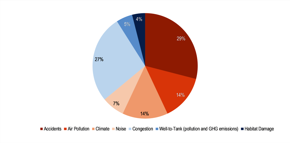
As reflected in Figure 5.1 accounting for well-to-tank emissions generated by the sector is also relevant. The Handbook estimates the total cost of GHG and pollution of well-to-tank transport emissions for the EU28 at EUR 31.2 billion in 2016, including 60% from climate change emissions (van Essen et al., 2019[14]).
Having accurate and disaggregated data on drivers of transport GHG emissions, such as transport volumes, share of electric vehicles, fuel efficiency and carbon intensity by type of vehicle, and car ownership, is key. Discussing these data requirements and indicators is beyond the scope of this report, which focused on indicators that can show ultimate outcomes and progress towards different goals. Institutions such as the International Energy Agency (IEA), the International Transport Forum at the OECD (ITF) and the International Council for Clean Transportation have focused on collecting data and supporting countries in improving this type of indicators. For instance, the IEA report Tracking Clean Energy Progress 2018 provides a number of indicators for transport and other sectors, reflecting short-term actions that are necessary to drive the transition towards clean energy (IEA, 2018[15]). The report indicates the necessary evolution of the selected drivers of emissions in the different sectors (at the global level) from now to 2030 in order to be consistent with the IEA Sustainable Development Scenario (IEA, 2018[15]).
5.3.2. Enhancing physical accessibility
As shown in Table 5.2, enhancing transport accessibility is linked to a number of SDG goals, and OECD well-being dimensions and domains. However, despite growing recognition of these links, there exists a need for “indicators that can be used to compare the quality of access delivered by different transport modes, at different territorial scales, and for distinct populations” (ITF-OECD, 2019[12]). These indicators will be key to tracking progress in the delivery of accessibility goals, as well as to developing accessibility-based decision-making frameworks, “i.e. policy, planning, and investment frameworks in which accessibility considerations are central criteria systematically guiding decisions” (ITF-OECD, 2019[12]).
The development of accessibility indicators is not new, but the number of indicators of this type has been growing. The increasing availability of spatial data has greatly contributed to this phenomenon (Geurs, 2018[16]). This subsection first explores how accessibility indicators could be used to monitor progress in the sector and its contribution to SDG targets and OECD well-being dimensions (summarised in Table 5.1). It then discusses in detail different types of accessibility indicators, and how these have been used in planning and appraisal in selected cities and countries.
SDG Target 11.2 calls explicitly for providing access to safe, affordable, accessible and sustainable transport systems. While useful, the indicator (proportion of population that has convenient access to public transport) selected by the SDG framework could be enhanced by accounting for frequency of service. In addition, tracking not only access to transport, but also access by public transport and other modes, and for different population groups to final destinations (e.g. jobs, education and health centres, etc.) is also key to understanding the sector’s contribution to a number of other SDGs and well-being objectives. Transport authorities (e.g. Transport for London [TfL]) and international organisations, such as the European Commission and the ITF, have done important work on this, by developing methodologies for computing indicators that go in this direction (see Table 5.5 and Box 5.4 in this section). Other indicators, such as a new approach developed by WhereIsMyTransport and applied to the City of Cape Town in South Africa, incorporate affordability and public security elements alongside physical accessibility to a range of relevant destinations (see Box 5.5). WhereIsMyTransport is a data platform for sustainable mobility in emerging markets that maps formal and informal public transport networks. All of these methodologies and indicators could be replicated in a number of cities, and thus could gradually become part of the indicators used for monitoring this target.
Access to employment is particularly central to delivering SDGs linked to employment and productivity. For instance, an evaluation of a subsidy scheme for lower-income households in Bogotá showed an increase in productivity as a result of increased public transport accessibility to economic activities (Peralta-Quiros and Rodríguez Hernández, 2016[17]). As such, indicators measuring changes in accessibility to employment are linked to SDG Target 8.5 (full and productive employment) and changes in the employment rate (an indicator used by the OECD well-being framework). In the same way, indicators measuring the levels and quality of physical accessibility to health and education centres will add valuable information on how the sector is contributing to SDG Target 3.8 (universal health coverage), as well as educational attainment (part of the “quality of life” domain and “education skills” dimension in the OECD well-being framework).
Together, indicators measuring transport access to health, education, employment and recreational centres can also add relevant information for understanding the sector’s contribution to social connections, a dimension recognised by the OECD well-being framework. While directly related to different dimensions of social, human and economic capital, good transport accessibility to different activities and points of interests are ultimately necessary to prevent social exclusion and eradicate poverty (SDG Target 1.1). “Broad evidence […] suggests that lack of, or poor access to transport options is central to limitations on access to jobs, educational institutions, health facilities, social networks, etc., which in turn generates a “poverty trap” (Lucas, 2018[18]).
The inclusion of transport accessibility to employment and other activities, especially through public transport, has also been increasingly recognised as a necessary element of housing quality (ITF-OECD, 2017[19]). Therefore, the level of accessibility from housing to different points of interest could also be included as part of indicators tracking the delivery of “good housing”. Housing is recognised as part of the “materials condition” dimension of the OECD well-being framework and by SDG Target 11.1, which calls for ensuring access for all people to adequate, safe and affordable housing. Chapter 4 on the residential sector develops this discussion in more detail.
Finally, accessibility indicators could also bring valuable information for keeping track of SDG Target 9.1, “develop quality, reliable, sustainable and resilient infrastructure … to support economic development and human well-being”. Indicators focused on access to frequent public transport services are important for identifying transport infrastructure gaps as well as the need for infrastructure upgrades across the transport system. In addition, developing indicators that allow comparing the levels of access provided to reach activities by different transport modes and population groups are key to identify particular gaps across territories, particularly in terms of sustainable transport infrastructure and vulnerable users.
Indicators on modal split, and the quantity and quality of infrastructure (e.g. data on allocation of road space and quality of infrastructure for different transport modes, such as median block size, share of roads with a low speed limit, bus rapid transit (BRT) lanes, bicycle lanes and facilities for freight transport would also be required to better track SDG Goal 9.1. As explained in Section 5.2, current indicators for this target (i.e. passenger and freight volumes) are not an adequate proxy for progress on delivering sustainable transport infrastructure. Rather, they tend to bias thinking towards a “predict-and-provide approach”, which has proved detrimental for prioritising sustainable transport options. The limitation of the current SDG Goal 9.1 indicators and the need for considering modal split, and particularly shares of more sustainable modes, has been raised by other organisations as well. For instance, the UN Economic Commission for Europe (UNECE) points out that a lack of compilation and interpretation guidance for the current indicators makes it difficult to determine progress on SDG Target 9.1. Some countries are reporting lower passenger and goods volumes as a negative, although it may simply indicate higher shares of active modes, lower commuting distances or efficient supply chains. The indicator and its metadata does not currently indicate how to assess progress (Blackburn, 2019[20]), but international work is now starting on this objective.
As discussed in Section 5.2, beyond the immediate links with sustainability and well-being goals explained above and reflected in Table 5.4. , the focus on enhancing accessibility is linked to climate change mitigation and other environmental and health benefits. First, an accessibility-based approach can recognise the value of and promote a central role for more sustainable transport modes (walking, cycling, public transport and other shared-trip services, including intercity rail). In addition, it allows increasing co-ordination between transport and land-use policy and planning, which is key to creating location-efficient and TOD patterns (see definitions in Box 5.1).The relevant role of these transport modes and the characteristics of the development patterns mentioned can generate widespread access, while significantly reducing overall distance, space consumption and travel, leading to lower GHG emissions and other negative externalities.
Research and analysis using accessibility indicators has multiplied as the relevance of generating not only social and economic benefits, but also environmental benefits, has become more evident. The use of accessibility indicators, particularly in the context of accessibility-based planning, is increasingly acknowledged as a way to “invert the growing unsustainability of urban settlement and mobility patterns” (Silva and Larson, 2018[11]). (ITF-OECD, 2019[12]), however, highlights that certain principles are necessary to ensure that accessibility-based frameworks effectively promote policies supporting sustainable development. Among these are using accessibility indicators that can: a) track accessibility needs for different transport users; b) reflect multiple modes of transport and their relative performance (specifically including sustainable modes like cycling, walking and public transport); and c) account for territorial differences (e.g. urban vs. non-urban territories), particularly acknowledging the neighbourhood scale.
TOD is commonly defined as a type of mixed-use urban development within close proximity (walking distance) to mass transit facilities. TOD principles are based on organising new development and redevelopment along mass transit corridors that serve as main transport axes, building high-density development along these corridors and fostering mixed land use and jobs.
Location efficiency refers to an urban development pattern where new housing developments are steered to locations that are affordable and can offer easy access through well connected sustainable transport modes.
Source: (ITF-OECD, 2017[19]).
Measuring accessibility requires having information reflecting its many determinants: land use (spatial distribution of activities), transport, temporal constraints and individual characteristics (e.g. income, gender). Different types of accessibility indicators can provide information on these different dimensions; within each type, simple and more complex indicators can also be developed. (Geurs, 2018[16]) divides accessibility indicators into four categories and analyses the characteristics, strengths and weaknesses of each type (Box 5.2). Within the different types of indicators, infrastructure-based and location-based measures are easier to operationalise, since they are less data-demanding, and are easier to interpret and communicate (Geurs, 2018[16]). Thus, these types of indicator have been more widely used by policy makers and planners. Examples in this section also focus on indicators from these categories.
a) Infrastructure-based measures focus on the transport component and provide insight on the relative quality of infrastructure throughout the transport network. Travel speed and congestion indices are examples of very simple measures of this type. More sophisticated examples can measure the average travel time needed to get to every location in an area from a specific location. The Public Transport Accessibility Level (PTAL) indicator used by TfL is another example (see more in Table 5.5).
b) Location-based indicators incorporate both the transport and land-use components. Contour- based or cumulative opportunity indicators are the simplest forms. These tools measure the number of opportunities (e.g. services, jobs) that can be reached within a certain time threshold, or the average time or cost needed to access a certain number of opportunities from a selected origin. Potential accessibility indicators are more sophisticated versions, which add an impedance function to calculations, i.e. a function that simulates the reduction in desirability of an opportunity in relation to the cost of travel (e.g. monetary, travel time). In some cases, indicators can also add competition effects i.e. the fact that opportunities are limited, which could also restrict access.
c) Utility-based indices estimate the welfare benefits that come with different levels of access to spatially distributed activities. They are based on modal-choice modelling tools and are thus a necessary input to calculating the indicators. Utility-based measures are highly complex, and thus more challenging to interpret, communicate and operationalise.
d) Person-based indicators quantify an individual’s ability to reach a certain location given spatio-temporal constraints, and according to the activities the individual needs to realise. The indicator in this case is calculated as the volume of a space-time prism, and represents the feasibility of opportunities according to space and time constraints. Person-based indicators are complex and data-demanding. As for utility-based measures, although rich in detail, they are relatively challenging in terms of communication, interpretation and operationalisation.
Person-based indicators are intrinsically linked to the temporal and individual components of accessibility. For the other type of indicators, using variants, differentiating between peak hours, population groups, transport modes and/or taking into account infrastructure quality can incorporate the temporal and individual elements. This allows linking accessibility to other policy goals (e.g. accessibility of lower-income groups and equity related issues, and sustainability and climate change mitigation).
Source: based on (Geurs, 2018[16]).
Accessibility indicators can improve transport planning if they are incorporated into the decision-making frameworks used by countries and cities. TfL, for instance, has developed a number of accessibility-based indicators (Table 5.5) that it uses to plan both the transport network, and commercial and residential development. Accessibility analysis based on these indicators has been at the centre of a number of policies, initiatives and infrastructure upgrades, which have allowed the City of London to double public transport’s modal share (from 25% to 50%) between 1995 and 2012. “This type of analysis […] enables TfL to understand where and to what extent sustainable transport options are available throughout London in accessing jobs and other amenities. This is important as the availability of public transport alternatives is obviously a clear driver of public transport mode share. Increased public transport use also correlates to higher use of active modes (walking and cycling) as these are often used as access and egress modes” (Inayathusein and Cooper, 2018[21]). It is estimated that if all Londoners walked or cycled for 20 minutes a day, the National Health System could save 1.7 billion GBP (British pounds) in the next 25 years (GLA, 2017[22]) and account for at least 60 000 years of healthy life (thanks to prevented illness and early death) each year for the next 20 years (GLA, 2018[23]).
Analysis based on accessibility indicators has been at the centre of a number of policies, initiatives and infrastructure upgrades, which have allowed the City of London to double public transport’s modal share (from 25% to 50%) between 1995 and 2012.
At the national level, the most recent Transport Investment Strategy published by the Department for Transport (DfT) cites the improvement of accessibility (referred to as connectivity) as one of its principal objectives. The DfT uses statistics and heat maps plotting accessibility to jobs by public transport and car across the country to identify infrastructure gaps and investment needs (ITF-OECD, 2019[12]).
The transport appraisal methodologies of the DfT and its Transport Analysis Guidance (WebTAG), a web-based tool to support appraisal, have also progressively widened the scope of accessibility impacts included in transport appraisal. This has helped overcome some of the challenges raised by critics of cost-benefit analysis, including that conventional appraisal methodologies’ heavy focus on travel-time savings tends to overlook the impacts on social inclusion/exclusion and favour motorised over non-motorised transport projects (ITF-OECD, 2019[12]). The framework developed by the DfT includes a number of monetised and non-monetised impacts. It presents decision makers with appraisal summary tables, which highlight non-monetised benefits and costs alongside the benefit-cost ratio (BCR). These tables provide more comprehensive information on whether the projects assessed are compatible with government objectives (ITF-OECD, 2019[12]) (see Box 5.3).
Transport appraisal in the United Kingdom is developed under the Value for Money (VfM) framework developed by the DfT. Different elements related to accessibility (physical access, affordability and safety) are included in these different impacts:
Established monetised impacts are the main inputs used to calculate the BCR; these impacts include journey time savings, impacts on accidents, journey quality and GHG emissions.
Evolving monetised impacts allow adjusting the BCR according to impacts that are relevant, but for which methodologies are less robust. These include journey time reliability, labour supply (i.e. the number of people who can access the labour market as a consequence to reduced commuting costs) and static clustering (i.e. improved connections between firms and households thanks to lower generalised costs of transport and related productivity gains).
Indicative monetised impacts and non-monetised impacts are used to inform VfM considerations, but not to estimate or adjust the BCR. Impacts in this assessment include security, severance, townscape, accessibility (in this context referring to usability by population with physical and hidden disabilities) and affordability. Methodologies under this assessment are continuously updated and improved by the DfT.
Source: (ITF-OECD, 2019[12]).
Accessibility indicators can also be used for benchmarking purposes. Indices like the TomTom Traffic index provide comparable and updated information on congestion levels in a number of cities, measured as the percentage of time added to the average trip due to congestion, compared to free-flow conditions. The social costs of congestion have been increasingly acknowledged, and congestion alleviation ranks high in the public and political agendas. As discussed earlier, congestion is estimated to account for 27% of the total external costs of transport (estimated at EUR 270 billion) in the EU28 (van Essen et al., 2019[14]).3 Having indicators on congestion helps keep track of the magnitude of the problem and the effectiveness of policies (e.g. congestion charging, addressed in the next section). However, an important caveat of measures taking free flow as a benchmark is that free-flow conditions are neither possible nor efficient (OECD/ECMT, 2007[24]). To avoid this caveat, the Joint Research Centre of the European Commission, in collaboration with the European Commission’s Directorate-General for Regional and Urban Policy (DG REGIO), has developed indicators that take as a base absolute accessibility and transport performance indicators, in this case for cars (see Box 5.4 for an explanation of these indicators), as well as other accessibility indicators, to measure the absolute and percentage changes to accessibility due to congestion during peak times. This work has been done for various cities (e.g. Seville, Brussels and Krakow), and future work is planned to cover all functional urban areas with more than 250 000 people in the European Union, plus other countries in Europe (Christodoulou, 2019[25]).
Benchmarking accessibility across territories can contribute to placing accessibility at the centre of what is considered good performance and can also be a valuable input for determining investment priorities. The ITF has developed a database with contour-based indicators on accessibility to services of different categories and through different transport modes for European cities. This is part of a project developed jointly with the OECD Centre for Entrepreneurship, SMEs, Regions and Cities (CFE), and supported by the European Commission.
The work builds on previous work from the ITF-OECD and the European Commission that measured accessibility to transport stops and other populations. The new indicators also calculate accessibility to final points of interest, i.e. different categories of services (shops, schools, universities, hospitals and green spaces). The database builds on available standardised open and crowdsourced data sets, and uses harmonised computational methods. The data set provides indicators for multiple transport modes: walking, cycling, public transport and car. Thus, it allows assessing the relative competitiveness of different modes, which is key to addressing environmental sustainability concerns. Working alongside the Inter-American Development Bank (IDB), the ITF also applied the framework to four Latin American cities – Mexico City, Bogota, Santiago de Chile and Montevideo – calculating indicators for accessibility to other population, jobs and basic services (i.e. education and health). Box 5.4 describes indicators in the European Commission-ITF-OECD Urban Access Framework, and shows some results comparing European and Latin American cities.
Among the most relevant challenges for tracking accessibility in cities from developing countries is the presence of informally or semi-formally run public transport. To overcome this challenge, the ITF and the IDB worked in partnership with WhereIsMyTransport for this project. Analysis shows that informal services can be central to delivering accessibility in some cities in developing countries (see Box 5.4). Nonetheless, it is important to take into account the quality of services provided by these modes and the issues that are often associated to them (e.g. safety, air pollution and GHG emissions). This highlights the importance of using physical accessibility indicators in tandem with a range of other indicators discussed throughout this section.
The indicators in the Urban Access Framework consider different modes of transport (walking, cycling, public transport and private car), and a number of opportunities (services of different categories) people actually want to reach. The methodology uses the harmonised definition of a city developed by the European Union and the OECD, according to which a “functional urban area” is a city and its surrounding commuting zone. The framework acknowledges that accessibility is the product of the proximity of valued destinations (the result of land-use policies) and of the performance of the transport system (the result of transport policies and investments in infrastructure).
The first indicator is absolute accessibility. The indicator reflects the absolute number of opportunities (e.g. schools, hospitals, jobs or other population that can be used as a proxy for concentration of activities) that can be reached by a given transport mode within a set travel time. This indicator highlights the differences in absolute access levels across cities or different areas, and allows comparing the levels of access delivered by different transport modes. However, accessibility in absolute terms tends to increase with city size. To overcome this city-size bias, two additional indicators were developed that reveal the contributions of the two main underlying factors in driving accessibility, i.e. the performance of transport systems and the structure of land-use development.
Land-use factors are reflected in the proximity indicator, i.e. the number of other populations, formal jobs, education and health opportunities located in a specific radius (2, 4, 8 or 16 km). Transport performance reflects the capacity of a given mode (car, public transport, bike or walking) to provide access to the opportunities located in proximity in a given time. This indicator is the result of a ratio between the absolute accessibility (overall number of opportunities reachable in a defined time threshold) and proximity (number of opportunities located in a defined radius). Using proximity as a fixed area of reference overcomes the small- and big-city-bias. This approach also separates the effect of urban form on accessibility from transport-service efficiency, which is essential for identifying service gaps and investment opportunities.
The framework was applied to benchmark accessibility levels in 121 European cities. The results suggest that cars tend to provide better accessibility than public transport or cycling, especially for longer travel times. For trips of 15 minutes, however, bicycles perform better in most cities. The results also suggest that people can access more destinations in dense cities despite higher levels of congestion, because people live close to many destinations and therefore make shorter trips. Nonetheless, cities with similar density can have different absolute accessibility levels, depending on the performance of their transport system.
Comparing public transport and car, the results reveal that in European cities, an average car driver can reach twice the number of opportunities accessible by public transport. London is an exception to the rule. Here, the public transport network is more extensive than in any other European city, while the road network performs comparatively poorly (the worst among the 121 European cities analysed). To a large extent, this the result of decisions not to build expressways in central London, coupled with recent policies to prioritise road space for public and non-motorised (cycling and walking) transport.
In the case of Latin American cities, cars also tends to be the most competitive option for providing access to a wide range of opportunities. This is the case even in Mexico City, one of the most congested cities in the world. In the Mexico City Metropolitan Area (Valle de México), in the space of one hour, public transport provides access to 30% of all jobs located within the urban centre, while cars provide access to 90% of all jobs. However, only 43% of the population own private vehicles, and cars are thus used predominantly by higher-income residents.
Results on accessibility to other populations in cities from both regions also show that despite huge differences in city size, public transport systems in smaller European cities reach a much higher number of people/opportunities (see Figure 5.2). In Paris, an urban area of 9 million people, an average resident can reach 40 times more people/opportunities than an average resident of Mexico City, an urban area of 30 million people. City size differences are also off-set in cities within regions. For instance, Santiago de Chile has 4.8 million population but absolute accessibility to other population by public transport is very similar to that in Mexico City. The estimation of proximity and transport performance indicators allows to identify that while higher proximity is created in Mexico City (due to higher density), the performance of the public transport system is better in Santiago de Chile.
The differences in absolute accessibility by public transport are even more visible when excluding the informal bus and micro-bus networks in Mexico City and Bogotá from the analysis. Informal transport modes (featured in the graph below) account for 54% of public transport accessibility levels in Mexico City and 35% in Bogotá. In both cities, informal transport also accounts for around 40% of accessibility to jobs provided by public transport. These networks make the biggest difference in terms of accessibility in peripheral low-income areas, as lower-income neighbourhoods often have inefficient or almost non-existent formal public transport.

Note: In the case of the Mexico City Metropolitan Area, formal transport refers to BRT, metro, light rail and regular buses (Nochebus, RTP). Informal networks include the loosely regulated micro-bus sector operating across the metropolitan area. In the case of Bogotá, formal transport refers to all the modes included in the Sistema Integrado de Transporte Público-SITP system (BRT and regular buses). Informal transport consists of loosely regulated privately operated bus services in the Southern municipalities of the Capital District, as well as across the municipalities outside of Capital District.
Source: (ITF-OECD, 2019[26])
5.3.3. Ensuring affordability of services and contribution to equity
Monetary costs can be incorporated into the accessibility indices described above, either reflecting both time and monetary cost in a single measure, or using separate indices to reflect each cost. As accessibility indicators become more complex (e.g. using potential rather than contour-based measures), it could be convenient to have separate indicators showing physical accessibility and financial accessibility, or monetary cost of access (ITF-OECD, 2017[19]).
Other types of indicators measuring the share of income (or disposable income) spent on transport can also be used. Moreover, combining transport with other relevant expenditures borne by households has provided better insights on the final impact of policy decisions on livelihood. The use of these combined indices can also help better integrate infrastructure planning if used by authorities in charge of the different sectors involved.
Housing plus transport affordability indicators are good examples of combined indices. Combining housing with transport expenses is particularly important because these tend to be highly correlated with location, but through the opposite relation, i.e. housing expenditures increase as housing location is more central and/or in more attractive locations, while transport expenditure increases as housing location is further away from central/attractive locations. The result is that households often need to make trade-offs between housing and transport conditions. Considering and incorporating both housing and transport expenditures into a same definition of affordability can help authorities improve households’ housing and transport situation. In addition, housing and transport expenditures are often the two largest household expenses, and are therefore extremely relevant to the disposable income households can use to cover other needs (ITF-OECD, 2017[19]).
Indicators of this type can contribute to tracking SDG Target 11.2, which also calls for affordable transport; currently, none of the selected SDG indicators measures affordability of transport services. In addition, they can complement information on household income used to track progress on the income and wealth dimension in the OECD well-being framework. Data on income levels can thus be analysed in the light of the share that different populations need to spend to cover two basic and related needs (transport and housing). In addition, these indicators can also add the transport dimension when tracking housing affordability and access to adequate housing (which also needs to consider the affordability of available transport services). As affordability of services is a key element of transport accessibility, these indicators are also linked to indicators related to income, employment, health and education (similarly to indicators measuring physical accessibility). Table 5.6 summarises the links between these indicators, the SDGs and the OECD well-being framework.
Income and expenditure surveys are relevant sources of data for calculating housing and housing plus transport affordability indicators. It is important to ensure that data analysis is conducted in a way that provides accurate results. For instance, accounting for income transfers and savings (e.g. for students or by the elderly) is important when breaking down population by income levels. In addition, in some cases the data groupings chosen may impede the management of data in a way that is useful (e.g. for calculating expenditures in transport and telecommunications) (ITF-OECD, 2017[19]).
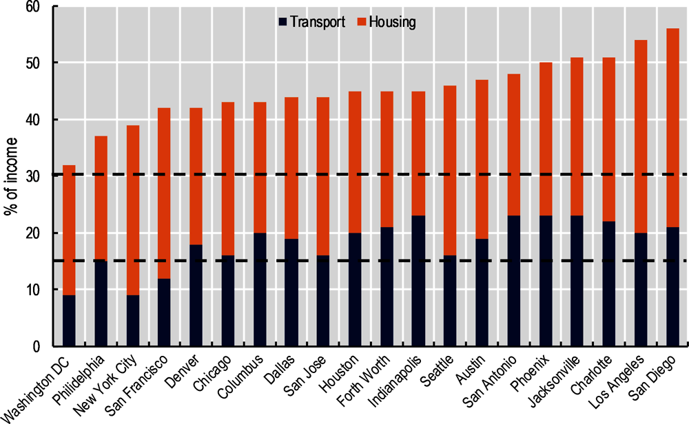
The Center for Neighborhood Technology (CNT) in the United States has developed a methodology for estimating housing plus transport affordability indicators. The resulting Housing and Transport (H+T©) Affordability Index was used to develop a national framework that calculates neighbourhood affordability within and across US cities. It also generates heat maps that present the results spatially. The thresholds used by the CNT for considering affordability are below 15% of household income spent on transport expenditures and below 30% of household income on housing expenditure. Figure 5.3 presents housing plus transport expenditures for a number of cities in the United States. It shows that the relative affordability of housing across cities is different when considering both housing and transport costs, as opposed to only housing. Cities like New York or San Francisco with average housing expenditures close to what is considered unaffordable (30% of income) rank better when combined transport and housing costs are accounted for. In contrast, cities like Indianapolis, where housing is on average a lower burden for households, do not rank as well when transport expenditures are included into affordability analysis.
Spatial analysis of affordability across cities using this tool has helped improve decisions at both the national and local levels. The H+T© Affordability Index has been used for implementing policies (e.g. subsidies for affordable housing) that promote transport-oriented and location-efficient development, delivering both climate change mitigation and affordability goals.
Figure 5.4 shows the overall correlation between transport-related GHG emissions in cities and the proportion of affordable neighbourhoods found in the United States (where affordability is determined by the compound H+T© Affordability Index of the CNT).
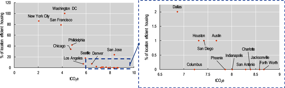
Evidence from the United States shows that cities with a higher share of neighbourhoods that have housing that is affordable in terms of both housing and transport costs have lower annual household CO2eq emissions from automobile use.
As in the case of accessibility indicators, using a range of provides more detailed insights. For example, (Guerra and Kirschen, 2016[28]) adapt the CNT methodology to the case of the Metropolitan Area of Valle de Mexico (Mexico City and the enlarged metropolitan area). The same thresholds used by the CNT for housing (30%) and transport (15%) expenditures were used to determine if a household is burdened or if housing is affordable. The authors use three variants of the CNT indicator: the proportion of households burdened by housing and transport costs; the average level of affordability for low-income households (defined as belonging to the 25th income percentile) across municipalities; and the percentage of housing options affordable to a household earning the 25th percentile income. All indicators are represented spatially for the metropolitan area.
Other useful indicators can be vulnerability indices: these can account for the cost burden imposed by current transport conditions or potential changes (e.g. implementation of a given policy) and incorporate spatial factors. Analysis of some policies (e.g. road pricing) have highlighted that fairness in regard to spatial distribution of people within the same income group (i.e. horizontal equity) has been as relevant as the potential impacts on different income groups (vertical equity) (ITF-OECD, 2018[29]), hence the importance of monitoring changes and climate policies with this type of indicator to avoid potential trade-offs. In (Mattioli et al., 2017[30]), the vulnerability index used to identify spatial vulnerability to increases in fuel prices across London takes into account exposure or the cost burden of travel, sensitivity and adaptive capacity. Cost burden is defined as household expenditure on fuel as a percentage of median income. Sensitivity is proxied using the median income in the region. Finally, adaptive capacity refers to accessibility through alternatives to car use, which in addition to being an important component for measuring equity, is key to understanding the potential modal shift. The accessibility indicators discussed in Section 5.2 are used to measure the accessibility to jobs and services by public transport and walking. The result showed that in London, the urban core tends to be less vulnerable to increases in fuel prices according to the vulnerability index, but pockets of the city are exposed to very high vulnerability. The findings underline the need to assess policy effects using disaggregated information, rather than focusing on average users (ITF-OECD, 2018[29]).
5.3.4. Ensuring safety and security
Injuries and deaths generated by crashes represent important social costs related to transport activity. The European Commission’s recent handbook estimating the external costs of transport in Europe reveals that accidents account for one-third of total external costs in the EU28 (Schroten et al., 2019[31]). The report finds that motorcycles, for instance, have the largest average external costs, owing to high accident rates and noise levels (Schroten et al., 2019[31]).
The number of road deaths and casualties is often used as a central indicator to analyse road safety. SDG Goal 3.6 sets as an explicit target to halve the number of global deaths and injuries from road traffic accidents by 2020 relative to 2015. As shown in Table 5.7, other indicators providing additional information on severity, type of road user and population group would contribute to disaggregated data to understand performance towards the SDG target. They can also contribute to tracking SDG Target 11.2, which mentions the need to ensure safe transport, but for which the SDG framework provides no specific indicator. They could also complement the OECD well-being framework (personal security dimension).
The latest report by the International Traffic Safety Data and Analysis Group (IRTAD)4 provides comparable indicators at the national level that reflect the current state and evolution of road safety for different user and age groups, road types and severity of injuries, as well as deaths (ITF, 2018). For instance, Figure 5.5 shows the change in road fatalities of car users and pedestrians for selected countries since 2010, using data collected by this group. It reveals that the number of pedestrian deaths is still going in many countries.
The ITF at the OECD is also running a network of road safety experts at city level called Safer City Streets. The network’s primary objective is to maintain a database of road safety indicators for cities to monitor and compare their progress against performance in other cities. Pedestrians, cyclists and motorcyclists make up 80% of fatalities in dense urban areas, which is why cities are encouraged to focus on protecting vulnerable road users. Road safety indicators should support and guide such efforts, by assessing and monitoring the level of risk experienced by specific road user groups. To do so, it is essential to measure and control for the volume of travel, i.e. the trips taken and distances travelled with each mode; only then can changes in modal split across cities and over time be accounted for. Road safety experts also recommend monitoring behaviours, such as speeding and seat-belt use. Beyond monitoring casualties, risk and behaviour, there also exists a need to monitor attitudes. Regular surveys should assess how complacent people are with risky behaviours, how unsafe people feel in traffic, and whether they would let their children walk or cycle. Work developed in the context of the Safer City Streets network is in line with these recommendations.
The ITF has computed risk indicators by mode as part of a project developed in partnership with the Centre for Entrepreneurship, SMEs, Regions and Cities (CFE), and supported by the European Commission. Indicators on outcomes (road fatalities) are normalised by mode and per population, daytime population, unit of travel and vehicle-kilometres in 60 European cities, and are available in the Road Safety in European Cities report (ITF, 2019[32]).
A particular challenge is that road safety indicators should track the true number of traffic fatalities and serious injuries. This can be done using a range of sources – including, of course, police crash data, but also complementary data sources. The monitoring and benchmarking of serious injuries is particularly difficult because a high number of serious injuries are not reported to the police and because of the need to consistently record severity levels; to this aim, medical injury scales such as the Abbreviated Injury Scale and the definition of a serious injury as MAIS3+ can be used.

Note: (a) Real data (actual numbers instead of reported numbers by the police). Data from Iceland and Luxembourg are not shown, since observations are too low to have meaningful percentage changes.
Source: (ITF-OECD, 2018[33]).
As highlighted in Section 5.2, improved road safety has several indirect impacts, including on climate change mitigation, that are often overlooked. These indirect benefits go beyond the obvious prevention of crashes, and the energy and material implications of repairing or scrapping vehicles. They can be less obvious when looking at the national level, but are tremendously important in cities. With shorter trip distances and larger scope for public transport services, cities have a tremendous potential for modal shift from private vehicles towards healthier, cheaper and less energy-intensive transport modes. However, road safety is often cited as the main barrier to people cycling (Santacreu, 2018[34]), (De Ceunynck et al., 2019[35]). In cities, therefore, there exists a direct link between road safety and the wider policy objectives of public health, inclusiveness and climate change mitigation.
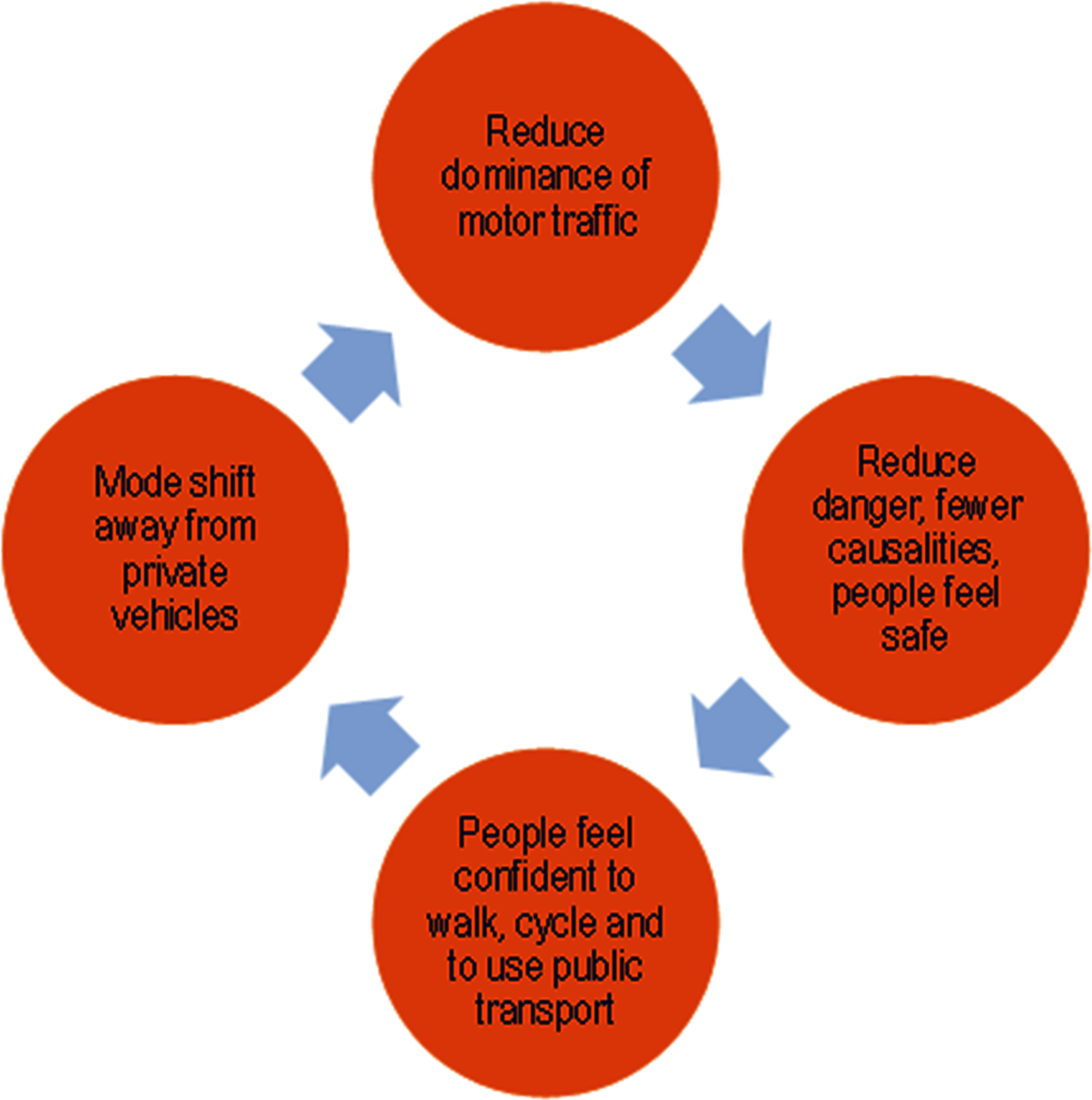
Progress on road safety can unlock modal shift and act as a catalyst for a virtuous circle: safer streets increase confidence to walk, cycle and use public transport (which generally implies increasing trips’ walking segments) (Mueller et al., 2018[36]). This improves the health of the population, which is more physically active; it can also reduce the amount of private motor-vehicle traffic, and related GHG emissions and local pollution. Thus, safer roads can support climate change mitigation strategies that focus on a modal shift towards more walking and cycling. Conversely, low levels of road safety may hamper the effectiveness of these strategies, as it prevents people from shifting towards non-motorised modes. In both cases, monitoring the risks associated with higher exposure to motorised traffic that could come from enhanced use of cycling and walking is relevant.
Source: (TfL, 2018[37]).
Work developed at the Catholic University in Chile complements accessibility analysis with the Environment and Urban Quality Index (EUQI), developed using pre-census data on sidewalk and street quality. Four sub-indices are calculated and serve as building blocks for the EUQI. The first sub-index is built from data on safety and security (i.e. luminary, road signs and roofed bus stops). The other three reflect walking environmental quality – environment (gardens, seats, sport fields and playgrounds); cleanliness (garbage bins and rubble); and infrastructure (sidewalk and street quality) – all of which are linked directly to improving mental and physical health (and thus with the priority below), including by encouraging walking. The EUQI index is used to complement a potential indicator (i.e. one using a decay function – see Box 5.2) that measures walkability to public transport in Santiago. This PAI calculates accessibility by foot to the ten closest transport stops (using a 400-metre threshold). Analysis using both indicators for measuring accessibility to public transport in the central business district, a higher-income (Las Condes) and a lower-income (San Miguel) neighbourhood, revealed that the lower-income neighbourhood ranked relatively high (just behind the central business district) when considering the PAI indicator only. However, the EUQI index showed that the quality of the quality of the walking environment (including because of safety reasons) to public transport in San Miguel was quite poor.
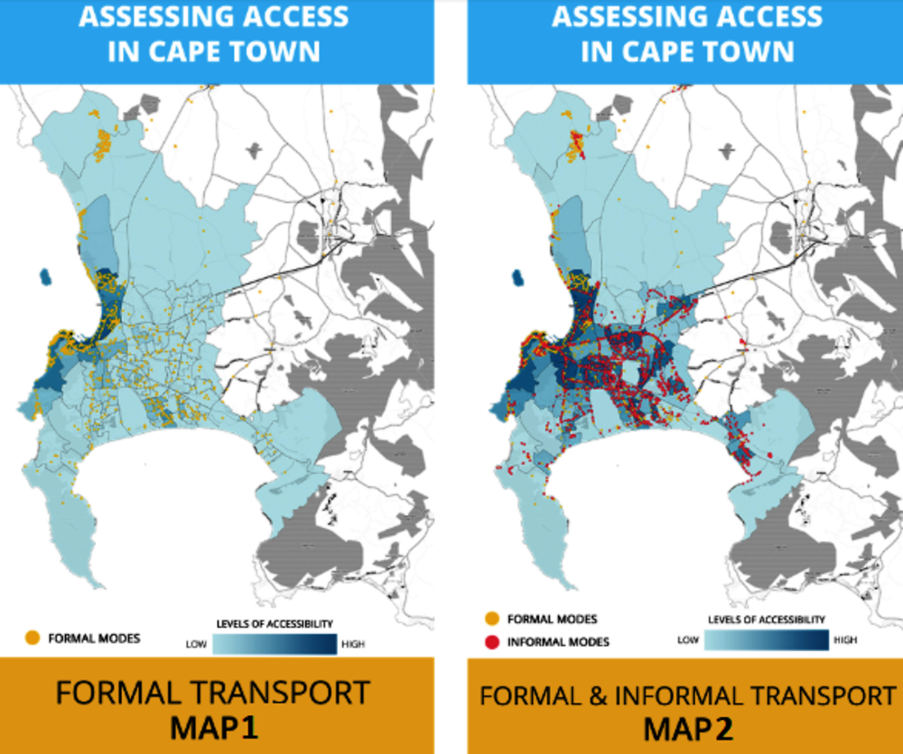
Another relevant example incorporating public security is a compound indicator developed by WhereIsMyTransport and used for analysis in Cape Town. The indicator combines spatial data on physical accessibility, affordability and public security (see Box 5.5).
WhereisMyTransport is the largest source of public transport data in emerging markets, maintaining data for more than 30 cities across 4 continents. It maps both formal and informal public transport networks, making this data available to governments and mobility service providers, which can use this information to make public transport more reliable, predictable, safe and inclusive.
Applying a new approach
To obtain a better understanding of accessibility in Cape Town, WhereIsMyTransport used a multi-dimensional approach: first, it collected and processed transport data for each transport agency active in Cape Town. The transport agencies included in this case study are Metro Rail, Golden Arrow Bus Services, MyCiti BRT and the Cape Town Minibus Taxis (2018). The data were used to generate a set of general transit speed specification (GTFS)extended files for each transport agency. The data were then uploaded to a platform that is designed to model multi-modal and informal transport journeys.
Three components that were considered central to understanding accessibility in emerging cities were selected for this indicator, defined as follows:
Physical access is the ease of reaching meaningful destinations (e.g. work, school, shopping and health services) from a particular location within a particular time or cost bandwidth. WhereisMyTransport used its API to run multiple journey-planning calls with the different transport agency data, and overlaid this information with “points-of-interest” census data to show the linkages between transport and access to social amenities.
Affordability refers to the cost of travel, which was determined using the fare data in WhereisMyTransport GTFS datasets, looking at fare cost alongside household income data to infer the percentage of income spent on public transport.
Safety has multiple dimensions. WhereisMyTransport evaluated safety by looking at waiting times for public transport, which was captured in the GTFS data sets. Data were overlaid with openly available crime statistics for the city of Cape Town. The output is an assessment of risk of exposure to crime based on the amount of time an individual would have to wait at a given public transport stop.
Figure 5.7 shows results when mapping the compound index in Cape Town. Map 1 illustrates accessibility in Cape Town when applying the multi-dimensional approach to the formal network. The dark blue neighbourhoods have the highest accessibility score (according to physical access, affordability and safety criteria). These neighbourhoods surround the Cape Town harbour and are part of the central business district. These are high-income neighbourhoods where residents primarily use private vehicles for travel and secondarily, the formal public transport system. This picture is missing the informal minibus taxi system, however, which is the most popular form of public transport across the city.
Map 2 illustrates accessibility in Cape Town when applying the multi-dimensional approach to both the formal and informal transport networks. By including the informal minibus taxi system in the analysis, a more accurate picture, on-the-ground picture of accessibility in the city is achieved. Low-income neighbourhoods and informal settlements are predominantly serviced by the minibus taxi network. Stemming from segregated spatial planning during the apartheid era, these neighbourhoods are located on the periphery of the city and rely on the minibus taxi network to gain access to employment and social amenities that lie in the city centre.
This case study of Cape Town highlights the importance of high-quality transport data in solving accessibility and future transport planning. It also shows that including the informally run transport system shines a light on the mobility patterns of a large proportion of Cape Town’s population. Conversely, excluding the informal system renders these citizens and their transport needs “invisible” in future city planning. Finally, it shows the importance of understanding access to public transport as multi-dimensional, which will allow policy makers, planners, operators and citizens to work together towards mobility systems that unlock freedom of movement – and freedom of opportunity – for everyone.
Source: Information provided by WhereIsMyTransport.
← General transit speed specification is a common format for recording data on transport schedules.
5.3.5. Reducing local pollution and noise, related health risks and habitat damage
Local pollution compromises air quality and harms health. The OECD estimated that the annual cost of pollution in terms of the value of lives and ill health amounts to around USD 3.5 trillion (US dollars) every year for OECD countries, plus the People’s Republic of China and India (OECD, 2014[38]). Data and indicators showing levels, sources and health impacts of local air pollution emissions are crucial to designing effective strategies. The European Environment Agency, for instance, has a database on premature deaths attributable to PM2.5, ozone and nitrogen dioxide exposure (the principal component of nitrogen oxide [NOx]) that includes data for 41 European countries. The World Health Organization’s (WHO) Global Health Observatory collects data for a majority of countries on mortality and burden of disease from ambient air pollution (expressed as annual deaths attributable to ambient air pollution). The WHO Global Urban Outdoor Air Pollution Database also gathers data on annual mean concentrations of PM2.5 and PM10 for a large number of countries and cities. Adopting general air quality standards that are consistent with international health standards set by the WHO is important to guide regulation in different sectors.
Specific data on transport-related local pollution are necessary to ensure that effective policies can be implemented in the sector. As Table 5.8 shows, it is particularly important that these data are available at the local – and even micro – level, for different pollutants and also from real-world emission testing. These data could contribute to a better understanding of the transport sector’s role in achieving SDG Target 11.6 (reduce the adverse per capita environmental impact of cities). Data could also expand on this by providing information on pollutants beyond PM2.5 and PM10 (e.g. nitrogen oxide [NOX] emissions), as well as help monitor the sector’s contribution to SDG Target 3.9 (mortality rate attributed to household and ambient pollution). In the case of the OECD well-being framework, indicators could also contribute to understanding transport’s contribution to environmental quality (currently measured only through national average PM2.5 concentrations). Accurate data on local air pollution emissions are an important input for ensuring that vehicle standards and policies promoting the renewal of the vehicle fleet can contribute to both GHG mitigation and pollution reduction, avoiding potential trade-offs between them. A number of studies highlight the relevance of using data that come from testing under on-road driving conditions, rather than laboratory certification testing (Box 5.6). The Handbook on the external costs of transport published by the European Commission provides relevant guidance for estimating air pollution costs from transport, as well as cost factors for individual European countries (for some pollutants differentiated by urban and rural areas), and a total cost estimate for the EU28 for 2016. The Handbook includes the following pollutants: NH3, NMV, SO2, NOx, PM2.5 and PM2.10. The total air pollution cost for the EU28 is estimated at EUR 71.8 billion, of which passenger transport accounts for 55%, mostly attributable to road passenger transport (54%).
As with GHG emissions, accounting for well-to tank pollution emissions (rather than tank-to-wheel emissions only) is necessary. The Handbook on the external costs of transport provides guidance and estimates for European countries on well-to tank emissions that include the following pollutants: NOx, non-methane volatile organic compounds (NMVOC), SO2, PM2.5 (exhaust) and PM10 (non-exhaust).The Handbook estimates that pollution makes up around 38% of total well-to-tank external costs from road transport in the EU28 (with the other 62% coming from climate change costs).
Noise from transport can also harm health and is an external cost that needs to be considered. The WHO has established that environmental noise is linked to a number of negative health impacts, including increased risk of ischaemic heart disease, stress-related mental health and cognitive impairment for children (WHO, 2007[39]). The WHO also finds that road traffic accounts for most community noise in cities. The European Environment Agency (EEA) estimates that 1 out of 4 Europeans (i.e. 125 million people) suffers negative impacts from road traffic owing to noise exceeding a 55 decibels (dB) Lden5 annual average (EEA, 2016[40]). While improvements in vehicles and roads are expected to help with this problem, growing urbanisation (which increases exposure) and increasing traffic volumes are expected to increase the overall negative impacts (van Essen et al., 2019[14]).
To indicate accurately health risks related to air pollution from transport, measurements of air pollution have to reflect on-road driving conditions rather than simply conditions in laboratory tests. In congestion, with stop-and-go traffic, for example, the difference between test-bed results and real-world monitoring of tailpipe emissions with on-board test equipment or roadside remote sensing can be considerable, skewing views on which technology is effective in protecting health. Real-world testing is a particular issue for diesel vehicles: only the most recent technology standards for heavy-duty vehicles (U.S. Environmental Protection Agency [EPA] 2010 and Euro VI) are able to account for real-world emissions; previous standards mandated technologies that only showed improvements in the laboratory.
Based on the impact of real-world conditions, there are two main recommendations: implement technology standards that include testing and enforcement in real-world conditions swiftly, and address adverse real-world conditions. For example, newer heavy-duty vehicle standards like U.S. EPA 2010 and Euro VI already perform well in early on-road tests. Countries developing new standards should use these as the benchmark and not adopt earlier EPA or EU standards that have been found to be deficient.
Source: Based on (ITF-OECD, 2017[41]).
The European Commission’s Handbook on External Costs of Transport (van Essen et al., 2019[14]) includes noise among the external costs of transport. While the suggested threshold for considering noise a nuisance is 50 dB Lden, estimations in the Handbook take a 55 dB Lden threshold, based on the EEA Noise Maps. Estimations for noise costs and cost factors (per unit of travel) are based on estimations of exposure and increasing prices per dB, themselves based on estimates by the UK Department for Environment, Food and Rural Affairs. As discussed in the Handbook, these estimates are consistent with WHO recommendations. Estimations also use weighting factors for noise for different vehicle types and type of roads, i.e. urban (up to 50 km/h speeds) and other roads (80 km/h or higher speeds). The total cost of noise generated by transport in the EU28 for 2016 is estimated at EUR 63.6 billion, with 67% stemming from passenger transport and 23% from freight road transport.
Finally, transport can also generate habitat damage, which the Handbook on External Costs divides into habitat loss (i.e. ecosystem loss, which can be the consequence of additional land dedicated to transport and have important impacts on biodiversity); habitat fragmentation (i.e. division of ecosystem due to transport projects, e.g. motorways or railways); and habitat degradation (i.e. negative impacts on ecosystems owing to the release of air pollutants and other toxic substance, e.g. heavy metals) (van Essen et al., 2019[14]). While the document also acknowledges other possible negative impacts (e.g. visual intrusions, light emissions from vehicles), it focuses on the three impacts mentioned, providing costs for the EU28 in 2016, and cost factors for different infrastructure and member countries. Estimations are based only on habitat loss and fragmentation costs, based on the methodologies developed for a study in Switzerland by the Swiss Federal Office for Spatial Development.6 The total cost for 2016 is estimated at EUR 39.1 billion.
This chapter discussed how shifting the focus of mobility policy and investment priorities from increasing physical movement to ensuring access to goods, services, opportunities and amenities is central to delivering ambitious climate and other well-being goals. It established a number of priorities for the sector that are key to supporting the delivery of wider well-being and sustainability goals (reflected by the SDGs and the OECD well-being framework). Finally, it argued that developing and using indicators that can translate these priorities into measurable outcomes for tracking progress and setting criteria is key to effectively place the priorities discussed at the centre of decision-making and identifying potential synergies and trade-offs of policies and interventions (including climate action).
References
[4] Aguilar Jaber, A. and D. Glocker (2015), “Shifting towards Low Carbon Mobility Systems”, http://www.internationaltransportforum.org/jtrc/DiscussionPapers/jtrcpapers.html (accessed on 30 June 2019).
[20] Blackburn, A. (2019), Transport SDG Indicators at UNECE,( presentation at Expert Group Meeting on Transport Indicators under SDG monitoring).
[13] C40 (2019), C40 Climate Action Planning Resource Centre, https://resourcecentre.c40.org/resources/measuring-ghg-emissions (accessed on 28 June 2019).
[25] Christodoulou, A. (2019), Measuring accessibility and congestion in European cities (presentation at the Expert Group Meeting on Transport Indicators under SDG monitoring).
[27] CNT (2018), Center for Neighborhood Technology, https://www.cnt.org/ (accessed on 3 July 2019).
[35] De Ceunynck, T. et al. (2019), Determinants and barriers of walking, cycling and using Personal e-Transporters: a survey in nine European cities, https://www.polisnetwork.eu/uploads/Modules/PublicDocuments/d1.1.2-a-survey-in-nine-european-cities.pdf (accessed on 3 July 2019).
[40] EEA (2016), Transport and public health — European Environment Agency, https://www.eea.europa.eu/signals/signals-2016/articles/transport-and-public-health (accessed on 3 July 2019).
[7] Fulton, L. et al. (2017), Transportation Three Revolutions in Urban, https://itdpdotorg.wpengine.com/wp-content/uploads/2017/04/UCD-ITDP-3R-Report-FINAL.pdf (accessed on 30 June 2019).
[16] Geurs, K. (2018), “Transport Planning With Accessibility Indices in the Netherlands Discussion Paper”, http://www.itf-oecd.org (accessed on 30 June 2019).
[23] GLA (2018), Mayor’s Transport Strategy, http://www.london.gov.uk (accessed on 3 July 2019).
[22] GLA (2017), “Draft Mayor’s Transport Strategy challenges and opportunities.”.
[28] Guerra, E. and M. Kirschen (2016), “Housing plus Transportation Affordability Indices: Uses, Opportunities, and Challenges”, http://www.itf-oecd.org (accessed on 2 July 2019).
[15] IEA (2018), Tracking Clean Energy Progress, https://www.iea.org/tcep/ (accessed on 25 June 2019).
[21] Inayathusein, A. and S. Cooper (2018), “London’s Accessibility Indicators: Strengths, Weaknesses, Challenges | ITF”, https://www.itf-oecd.org/london-accessibility-indicators (accessed on 28 June 2019).
[2] IPCC (2018), IPCC: Global Warming of 1.5 C, https://ipcc.ch/report/sr15/ (accessed on 17 October 2018).
[5] ITF (2019), ITF Transport Outlook 2019, OECD Publishing, Paris, https://dx.doi.org/10.1787/transp_outlook-en-2019-en.
[32] ITF (2019), Road Safety in European Cities Performance Indicators and Governance Solutions Case-Specific Policy Analysis, http://www.itf-oecd.org (accessed on 29 July 2019).
[8] ITF (2018), Policy Directions for Establishing a Metropolitan Transport Authority for Korea’s Capital Region Case-Specific Policy Analysis, http://www.itf-oecd.org (accessed on 30 June 2019).
[3] ITF (2017), ITF Transport Outlook 2017, OECD Publishing, Paris, https://dx.doi.org/10.1787/9789282108000-en.
[26] ITF-OECD (2019), Benchmarking Accessibility in Cities, https://www.itf-oecd.org/benchmarking-accessibility-cities (accessed on 3 July 2019).
[12] ITF-OECD (2019), Improving Transport Planning and Investment Through the Use of Accessibility Indicators Case-Specific Policy Analysis, http://www.itf-oecd.org (accessed on 28 June 2019).
[33] ITF-OECD (2018), Road Safety Annual Report 2018, http://www.itf-oecd.org/road-safety-annual-report-2018 (accessed on 3 July 2019).
[29] ITF-OECD (2018), The Social Impacts of Road Pricing Summary and Conclusions, http://www.itf-oecd.org (accessed on 3 July 2019).
[19] ITF-OECD (2017), Income Inequality, Social Inclusion and Mobility Roundtable Report 2017 Income Inequality, Social Inclusion and Mobility, https://www.itf-oecd.org/sites/default/files/docs/income-inequality-social-inclusion-mobility.pdf (accessed on 4 June 2019).
[41] ITF-OECD (2017), Strategies for Mitigating Air Pollution in Mexico City | ITF, https://www.itf-oecd.org/strategies-mitigating-air-pollution-mexico-city (accessed on 23 June 2019).
[10] Litman, T. (2008), Evaluating Accessibility for Transport Planning Evaluating Accessibility for Transportation Planning, http://[email protected] (accessed on 30 June 2019).
[18] Lucas, K. (2018), “Editorial for special issue of European transport research review: transport poverty and inequalities”, European Transport Research Review, Vol. 10/1, p. 17, https://doi.org/10.1007/s12544-018-0288-6.
[6] Luderer, G. et al. (2018), “Residual fossil CO2 emissions in 1.5-2 °c pathways”, Nature Climate Change, Vol. 8/7, pp. 626-633, https://doi.org/10.1038/s41558-018-0198-6.
[30] Mattioli, G. et al. (2017), Developing an index of vulnerability to motor fuel price increases in England, http://eprints.uwe.ac.uk/30778/1/Mattioli%20Philips%20Anable%20Chatterton%202017%20Developing%20an%20index%20of%20vulnerability%20to%20motor%20fuel%20price%20increases%20in%20England.pdf (accessed on 3 July 2019).
[36] Mueller, N. et al. (2018), “Health impact assessment of cycling network expansions in European cities”, Preventive Medicine, Vol. 109, pp. 62-70, https://doi.org/10.1016/J.YPMED.2017.12.011.
[9] OECD (2016), Multi-dimensional Review of Peru: Volume 2. In-depth Analysis and Recommendations, OECD Development Pathways, OECD Publishing, Paris, https://dx.doi.org/10.1787/9789264264670-en.
[38] OECD (2014), The Cost of Air Pollution: Health Impacts of Road Transport, OECD Publishing, Paris, https://dx.doi.org/10.1787/9789264210448-en.
[24] OECD/ECMT (2007), Managing Urban Traffic Congestion, http://www.cemt.org (accessed on 30 June 2019).
[1] OECD/IEA (2019), “CO2 Emissions from Fuel Combustion”, http://dotstat.oecd.org/?lang=en#.
[17] Peralta-Quiros, T. and C. Rodríguez Hernández (2016), Balancing Financial Sustainability and Affordability in Public Transport, http://www.itf-oecd.org (accessed on 2 October 2018).
[34] Santacreu, A. (2018), Cycling Safety, http://www.itf-oecd.org (accessed on 3 July 2019).
[31] Schroten, A. et al. (2019), “Sustainable Transport Infrastructure Charging and Internalisation of Transport Externalities: Executive summary”, https://doi.org/10.2832/246834.
[11] Silva, C. and A. Larson (2018), “Challenges for Accessibility Planning and Research in the Context of Sustainable Mobility | ITF”, https://www.itf-oecd.org/challenges-accessibility-planning-sustainable-mobility (accessed on 30 June 2019).
[37] TfL (2018), Vision Zero action plan, http://content.tfl.gov.uk/vision-zero-action-plan.pdf (accessed on 3 July 2019).
[14] van Essen, H. et al. (2019), “European Commission”, https://doi.org/10.2832/27212.
[39] WHO (2007), Housing, Energy and Thermal Comfort Housing, Energy and Thermal Comfort A review of 10 countries within the WHO European Region The WHO Regional Office for Europe, http://www.euro.who.int/pubrequest. (accessed on 1 July 2019).
Notes
← 1. A 1994 report developed by the Standing Advisory Committee for Trunk Road Assessment in the United Kingdom provided an important reference on evidence of induced demand (OECD, 2016).
← 2. N2O and CH4 emissions are converted to CO2eq using the Global Warming Potential.
← 3. This estimate is based on delay costs; deadweight lost costs are estimated at EUR 46.2 billion.
← 4. IRTAD is a permanent group dedicated to road safety in the ITF-OECD. With 80 members from 41 countries, the group has the objective of improving knowledge about road safety. It serves as a forum for countries to exchange information on methodologies for data collection and analysis.
← 5. Weighted average between day, evening and night noise.
← 6. INFRAS en Ecoplan, 2018. External Effects of Transport 2015 in Switzerland (‘Externe Effekte des Verkehrs 2015’). Update study of the calculations of environment, accident and health costs of road, rail, air and water transport 2010-2015, Bern: Swiss Federal Office for Spatial Development.